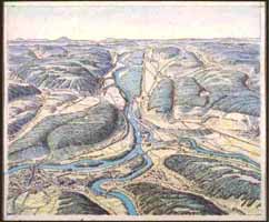
- Junction of Aare, Reuss and Limmat, bird's-eye view.
Original
pen-and-ink drawing, painted in watercolors. For the
Schweizerische Sekundarschulatlas, editions 1934-1961. 14 x 17
cm.
(Imhof, Eduard F 8)
|

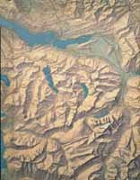
- Lake Garda 1:750 000
Hilll-shading to be used by the
hachures engraver.
Pencil on blueprint of the topographical
situation.
For the Schweizerische Sekundarschulatlas,
editions
1934-1961. 14 x 9 cm. (Imhof, Eduard F 58)
|