|
|
Bird's-Eye View mapsThe so-called bird's-eye view maps
(oblique views) stands between the artistic perspective view and
the map itself. It is a picture drawn or photographed at an
angle from above as seen through the eyes of a bird. It helps to
understand the map which is usually harder to interpret and is
therefore often found in the introduction to school atlases.
Bird's-eye views are also popular for touristic advertising or
as a souvenir. |
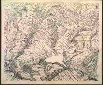
- Lac de Montsalvens (reservoir) near Broc. Bird's-eye view
Pen-and-ink drawing, black ink. Original 1932 for an
illustration in the
Schweizerischer Sekundarschulatlas,
editions 1934-1961. 14 x 17 cm.
(Imhof, Eduard F 7.1)
|
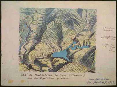
- Lac de Montsalvens (reservoir) near Broc, bird's-eye view
Watercolor
(F 7.1). 1933.
Schweizerischer Sekundarschulatlas, editions
1934-1961.
19 x 25 cm. (Imhof, Eduard F 7.2)
|
|